Three NUST students, conducting their Master thesis in the context of SASSCAL’s Research Portfolio, presented their work at the 60th Annual Symposium of the International Association for Vegetation Science (IAVS) in June 2017 at Palermo, Italy.
The three NUST posters presented: Impact of a Rainfall Gradient on above and below Ground Carbon Storage in the North-Eastern Namibian Dry Woodland Ecosystem, Vegetation trends of woody plants and grasses in the Kalahari, north-east Namibia & A vegetation classification of The Nama Karoo Dwarf Shrub savanna in South Central Namibia
Amber Nott presented her thesis for her Master in Applied Science in Earth Observation , GIS and Remove Sensing, “Impact of a Rainfall Gradient on above and below Ground Carbon Storage in the North-Eastern Namibian Dry Woodland Ecosystem” (Supervisor: Dr Nicky Knox):
Amber in front of her poster in Palermo, Italy
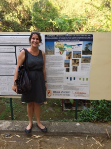
Amber taking non-destructive tree height measurements using a Vertex laser
Namibia is currently a signatory to the United Nations Framework Convention on Climate Change (UNFCCC) as a non-Annex I party. As a non-Annex I party, Namibia is required to ‘provide information on greenhouse gas inventories’, but the responsible ministry lacks sufficient baseline data. Also, Namibia is not involved in the United Nation’s Program for Reduction in Emissions from Deforestation and Forest Degradation in Developing Countries (REDD+). By assessing the carbon storage capabilities in the largest woodlands of Namibia, there will be an opportunity to become involved in this programme while conserving the country’s woodlandsAmber’s research questions are:
- To determine whether rainfall results in statistically different tree-parameters measurements (non-destructive) in the tree species investigated.
- Determine whether rainfall influences woody biomass for either P. angolensis or B. africana.
For her methodology, Amber chose 4 study sites along the natural rainfall gradient from the Kavango West to the Zambezi Region where both species occur. Non-destructive sampling was conducted at all sites. At these sites, multiple tree parameters (height, crown, stump diameter, etc.) were measured in 5 dbh classes from 5cm – >45cm. A total of 40 samples for each species were taken at each site. In addition, at one site, destructive sampling was conducted where the above and below ground woody components where weighed in the field and the sample wood discs and roots were dried in the lab to calculate the dry biomass. From the destructive sampling site, allometric biomass models were derived and extrapolated using the measured non-destructive parameters to the remaining 3 sites.
Emma Shidolo presented her Master thesis of Natural Resource Management “Vegetation trends of woody plants and grasses in the Kalahari, north-east Namibia” (Supervisor: Dr Ben Strohbach):
The Kalahari landscape has been described as especially vulnerable to global climate change, with wide-spread remobilization of dune fields being predicted over the next 50 to 80 years. Situated in the northern and central Kalahari in Namibia, the Mile 46, Sonop and Sandveld Biodiversity Observatories are found on state farms in one of the prime beef production farming area, whereas Mutompo observatory is located on communal land in the same area. The regular monitoring over the past years show how vegetation in the area responds to climate variability in rainfall together with grazing impacts.
Emma at the symposium venue in Palermo
The results demonstrated that vegetation cover increases as rainfall increases along the rainfall gradient. Shrub cover initially increases in a positive correlation/response to rainfall, however as rainfall increases further the shrub cover begins to decrease. This is because of the introduction of fire events that are found to occur in areas of higher rainfall. Tree cover consistently continues to increase as rainfall increases. However, grass cover increases or decrease as an opposite response to shrub cover. This trend is a result of competition for available resources between the shrubs and the grasses.
Another vegetation trend along the rainfall gradient is that broad-leafed woody plants increase in cover from areas with low rainfall to areas with high rainfall, whereas fine-leafed woody plants increase the cover in the opposite direction.
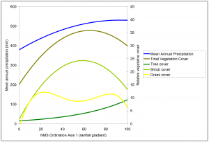
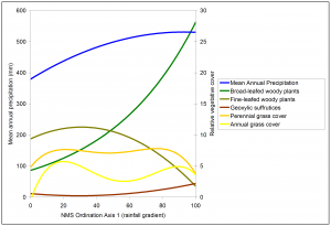
(Top) Graph demonstrating the correlation between increasing annual precipitation, total vegetation cover, tree cover, shrub cover and grass cover; (Bottom) Graph representing the correlation between increasing annual precipitation broad-leafed and fine-leafed woody plants
Nabot Mbeeli presented his Master thesis in Natural Resource Management “A vegetation classification of The Nama Karoo Dwarf Shrub savanna in South Central Namibia” (Supervisor: Dr Ben Strohbach):
The Nama Karoo is a xeric shrub land ecoregion located on the central plateau of South Africa and Namibia. It occupies most of the interior of the western half of South Africa and extends into the southern interior of Namibia. The Nama Karoo is bordered by the Succulent Karoo to the south west of Namibia and extends down into South Africa. The Succulent Karoo is described as the Nama Karoo with winter rainfall, making it a habitat with a different biota from the Nama Karoo. Vegetatively, the Nama Karoo is characterised by chamaephytic-hemicryptophyitic co-dominance, i.e. shrubs and grasses make up most of the perennial plant life, with trees absent except along watercourses, while forbs only appear after rain.
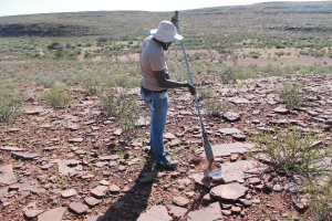
Nabot collecting a soil sample for lab analysis using a soil auger in the Nama Karoo
Based on a survey during the 2016 rainfall season, Nabot identified four higher hierarchy vegetation units that correspond to the broader landscapes of the river valley associated with the Fish – Lewer – Konkiep River Systems, the Central Plains, the Eastern Weissrand Plateau and the Western Escarpment Zone. Further subdivisions of the larger hierarchical units resulted in 16 vegetation units of the Central Nama Karoo.