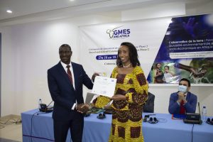
The SASSCAL Executive Director Dr Jane Olwoch receiving the GMES and AFRICA 2nd phase grant certificate
during the Award ceremony
The Global Monitoring for Environment and Security & Africa (GMES and Africa) is an initiative between the Africa Union and the European Union in the area of space science & technology and a key priority under the EU-Africa partnership. GMES & Africa aims to promote development of local capacities, institutional, human and technical resources for access to and exploitation of Earth Observation (EO) based services on an operational basis for sustainable development in Africa.
On the 14th of March 2022, the GMES & Africa support programme, awarded 8 consortia across the 5 regions of African continent with grants, making GMES a truly Pan African initiative. It aims to cover the entire supply chain for services on Water & Natural Resources and Marine & Coastal areas from access to information, generation and provision of services, and engagement and capacity of users to ensure utilization of these services. GMES and Africa Phase 2 started in January 2022 and will end in December 2025.
A consortium led by SASSCAL was amongst the recipients. The SASSCAL Executive Director Dr Jane Olwoch received the grant certificate on behalf of the SASSCAL-led consortium during the Award ceremony in Cotonou, Benin on 14 March 2022.
WeMAST Phase II intends to ensure the automation and widespread uptake of the already developed Geoportal services to target groups and end users, including river basin commissions and national water/environmental institutions. The consortium’s EO-based services will be in sync with other related EO based projects and programmes in a way that enhances their incorporation to the decision-making processes in the SADC region and African continent at large.
To ensure skills and technology transfer, SASSCAL have partnered with like-minded institutions and the private sector during Phase I in the development of the Wetland Monitoring Geoportal. Phase I of the WeMAST project developed and implemented an EO-based platform that supports Sustainable Wetland Assessment and Monitoring Services to promote policy and management practices in the SADC region and beyond, utilize open-source Satellite-based EO data and existing free software that will continue to be explored in Phase II.
WeMAST Phase II Project aims to upscale and operationalize the developed EO-based platform that supports Sustainable Wetland Assessment, monitoring services, promote policy, and management practices in the SADC region and beyond.


